Are tablets taking the place of chart plotters?
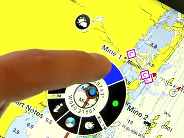
In last Friday’s post titled What Would You Pack In Your Bag, the owner and developer of Active Captain, Jeffrey Siegel, recommended a GPS-capable iPad with charting software installed. For the record, my iPad mini with Garmin Bluechart Mobile installed on it will definitely be traveling with us. This initiated a conversation for us though, are tablets taking the place of actual marine chart plotters?
Of course, having redundant systems is always the best answer but for those with limited cash, what’s the best to buy? Off the top of my head, the one feature that I can think of that a tablet is not able to do is directly interface with a boat’s autopilot. Is that feature alone worth the additional money?
I had also heard a suggestion that the internal GPS of the iPad may not be sufficiently accurate, hence the availability of aftermarket external GPS antennas that can be either hardwired to the iPad, or linked by Bluetooth. My limited research (Google) did not seem to back that up. I found only references to airplane pilots using these, and not for accuracy issues but for reliability reasons (you definitely wouldn’t want to lose your GPS signal on final landing approach if that was your only method of navigation). Is that necessary for a mariner though?
And while we’re on the subject of tablets, if you’re presently using one, what is your favorite charting app?
Not Ken Page….no sir. Aged charts, a sextant, and knotted line will do.
Without a doubt.
I for one am using a tablet in place of a conventional hard-wired chartplotter. My boat never had one to start with so I went for the cheapest (and safest) option. My 7″ Samsung Tab4 is loaded with Navionics Gold – Mediterranean and Europe (39 euros!!!).
The software has been fantastic and accurate enough in all conditions. I have it connected via wifi to my smart phone for an extra 3/4G accuracy. The advantage of the tablet is at the wheel, where it is housed in its waterproof case, I can also check weather updates. It is multi-functional, which I like!
There is no issue for me with regards the auto helm as mine is a stand alond wheel pilot. Even with a top of the range chartplotter I wouldn’t be able to connect them.
Thanks for sharing.
Any “Nibbles” On Z2C?
Yes.
I love Active Captain and had it loaded on an iphone in a Snow lizard case. On a small sailboat the case was destroyed in 3 months of active sailing. Now I’m looking for a robustly built chart plotter -and a bigger boat, but that’s another story. Tablets are nice, but relatively fragile.
The “waterproof” cases presently available for tablets and phones leave a lot to be desired.
I have a little different perspective, as my #3 passion is racing, and I have a Factory Five Racing 818R that I campaign at Autocross and TT events. Generally the GPS chip on a tablet or smartphone are accurate to within 3m. Bluetooth GPS receivers can be more accurate for two reasons. One reason is that maybe your tablet does not have WAAS. The other reason is that the Bluetooth receiver will generally have WAAS, as well as a higher refresh rate, for example 10hz instead of 5hz. From a racing perspective the higher refresh rate gives better info when you are going 50-150MPH. Most all have a data collector that has an external GPS, but some of us have a 7″ Android tablet with a Bluetooth GPS mounted somewhere on the roll bar.
Good info.
I use a Pantech Element tablet which is supposedly waterproof to something like 3m for 30 minutes, although I’m not looking for a chance to test that feature. I keep it at the helm – with AC and Navionics – and am very happy with it. If I have wifi or a cell signal, its usefulness knows no limits! One minor drawback: the display is not bright enough in sunlight but that is easily resolved by quickly casting a shadow with one hand for the few seconds that I need to view it. My autopilot is so old that even if I could attach it to a plotter I doubt the 2 devices would communicate. It would be like trying to send 802.11 to a device that only receives morse code.
Marine chart plotters are so expensive and limited in their capabilities compared to tablets that, to answer the article’s question, I believe tablets (especially with appropriate protection) are a clear choice for many sailors.
I liked the morse code reference.
Hmmmmm….lets see…
$500 Windows Tablet running Polar Navy or OpenCPN where I can download weekly updated FREE ENC charts from NOAA.
vs
$600 Garmin (or any other Proprietary Chart brand) Chartplotter (smaller window same price) where I pay to have my Cartography updated.
You guy’s actually discuss this?
We are talking updated Navigation?
Perhaps we should all stick with 19th Century Navigation tools like the guy with the sextant.
Hardly a fair comparison.
I will continue to use a dedicated chartplotter (Simrad NSS7 Evo2) and augment that with an Android tablet with Navionics charts. I seem to be finding a lot of iPads w GPS out there and the friends I know swear by them. Not too sure if it ia an Android vs iPad thing but suspect it is.
I do have a sextant with limited skills using it. I can do it if I have electronic tables but do not know how to render with clock, paper and pencil. I wish there were more courses on this subject because I need to be spoon fed.
I keep detailed book form paper charts of areas I sail. I like referring to them as I come from the pilotong era of paper charts.
Having redundant systems is the best.
I think there is a definite place for the $600 Garmin chartplotter. Take one wave outside the boat with the iPad and it goes away forever. Use the Android tablet while underway in the Bahamas and you’ll be looking at a black screen because the sunlight will wipe out the display. Add a waterproof cover and watch the whole thing burn up in the Caribbean sun because it’ll overheat.
Dedicated chartplotters combine water resistance, sunlight readability, and shock protection. They are designed to work reliably in the outdoor, boating environment. If you added that engineering to the iPad, it would be triple the cost too.
Chartplotters today also allow full instrumentation connectivity (depth, wind, autopilot, AIS, etc) along with full radar support. I’d expect each of those specialties to fall away in the next couple of years. I’m working myself on helping to make better wireless instrument interfaces. Radar will be the tough one although we’re starting to see iPad radars with Furuno’s new unit too.
I think the smartest, safest navigation electronics choice is to use a combination of hardware chartplotters and off-the-shelf tablets and phones. That gives the best capabilities for every environment. Nothing beats an iPad, in my option, as a backup charting device. Every boat should have some type of tablet like that onboard.
Thanks, Jeffrey.
iNavx on the tablet allows you to interface with an autopilot when your NMEA network is connected to a wifi router. Which is easy to do.
I didn’t know that.
We’re on our shakedown cruise and this boat didn’t come with any built in navigation electronics. So we’re using an old iPad 2 with navionics with paper backups.
Cons:
-Horrible to see in bright sunlight (ie all the time)
-iPads overheat and turn off (happens quite frequently when laying in the sun by helm)
-Tablets are not hard wired to battery bank. Our (old) iPad needs charging mid passage.
-Older tablets have no or bad quality GPS. We use a Bluetooth connected “Baf elph” external gps device. Nice backup to have regardless.
-Tablets don’t interface with radar, AIS, auto pilot, or other boat systems.
-They bounce around the boat in any kind of weather.
-The pinch/drag gestures are impossible when screen is wet which happens frequently in rain squalls or bad weather.
-Navionics sucks for any kind of passage planning/marker plotting etc
Pros:
-cheap
-nice independent backup
We’re getting a dedicated helm mounted Garmin system once we’re stateside.
Always good to list the pros and cons.
Tablet all the way. Every time I’ve sailed on a boat with a built-in chartplotter, I use my iPad with Garmin or iNavX and it proves to be at least as accurate, if not moreso. The touch interface is great (no stupid softbuttons or joystick), and Garmin for one has integration with activcaptain right on the chart – super useful.
Just make sure you get a tablet that actually has a GPS chip, and not just cell/wifi triangulation for location services. For example the iPad only has an actual GPS chip if you buy the cellular version (whether you use the cellular service or not is irrelevant). The wifi-only iPads do *not* have a gps chip built in (unless they’ve changed it in more recent models).
What is more accurate, the GPS or the charts that are displayed?
I have Navionics on my iPhone 5s. We do not use it for navigation directly because it cannot drive our autopilot. (Aside: I spent quite a while this morning trying to find a bluetooth receiver that would accept XTE sentences and translate them to NMEA 0183 for the autopilot. No dice. And I’m not even certain that the Navionics app can output XTE sentences.) But it is a good backup should our chartplotter fail.
One thing I have noticed when running both devices side by side tho, is that the GPS in the iPhone is a lot flakier than the one in the chartplotter. While the chart plotter shows us more or less going on a straight line, the iPhone has our course vector veering all over the place on occasion. This would be a disaster if fed to an autopilot.
bob
s/v Eolian
Anacortes
Interesting.
I have a 10″ Samsung Android tablet and Navionics. I am delighted with it.
It is the main reason that I bought it and at £350 (?) it is good value. Compare that with a power hungry chart-plotter either too small to be able to see well, or too big and nowhere to put it.
It is not linked to my new (2nd hand) auto-pilot. That suits me. I still want to be in charge of what is going on.
Mike
I should add that I have paper charts as well.
Having the autopilot linked to the plotter doesn’t mean that you’re not in control. It just allows the autopilot to automatically adjust for leeway when directed to navigate towards a waypoint. Without that, you need to make manual adjustments.
Brookhouse iMux can handle multiple inputs (NMEA or SeaTalk) including AIS and output to its built-in wireless access point. iPad with iNavx can then display AIS targets, heading, track etc plus I believe it will handle XTE out from the iNavx/iPad to your Autopilot.
Having said that, I think the iPad makes an excellent backup or secondary charting device but prefer to have an actual marine chart plotter as primary when the going gets tough.
Googled it:
http://brookhouseonline.com/imux.htm
Redundancy is the key. Absolutely have a tablet, with at least one charting app. We use OpenCPN on a boat 12V PC (which also has Garmin Blue Charts), a small Garmin Chartplotter (with a world-wide base map, our chart chips are no longer useful and its too expensive in the South Pacific), an iPAD (with Navionics App – which doesn’t support Active Captain unfortunately) and a laptop PC with both OpenCPN and Garmin Blue Charts loaded. You don’t need a chart plotter at the wheel except when you’re coming into or out of an anchorage or harbour. Finally, I wouldn’t be caught dead with any chart plotter controller my autopilot. That’s not reliable enough, way too dangerous.
How is it is any more dangerous than simply setting a heading and clicking GO?
i’ve used both, close to shore but have never tried a tablet in open water. i’d wonder how consistent and accurate they’d be when doing a open water crossing? i’d agree with all the points above abot the chartplotter being built for the environment. the ipad is a great backup, good for course plotting in the pub 🙂
I don’t know what it would be any less accurate at sea than it is in coastal areas.
My problem is the touch screen. The first time I tried my tablet it was very rough, and everytime I tried something it seemed I ended up on different menu or with the screen inverted. Picture me in a near gale, just laughing hysterically at the impossibility of it. It was funny because I have it mounted next to a conventional plotter with buttons, which I could still use.
At first they came out with touch screens… and then they added the buttons back, since you can work the buttons when it’s kicking, when the touch part can be inoperable. And then there is the matter of gloves.
As back-up nav or for planning, great stuff.
You’re right, the manual buttons are sometimes a pain but in rougher conditions, they may be superior.
Just returned today from another 8-day trip in the BVI’s where we logged over 200nm. The FP Lipari we chartered from TMM had a wonderful built-in chart plotter at the nav station- but not out at the helm. I found myself using my iPad at the helm full time and abandoned the state-of-art chartplotter inside. My iPads (yes – 2 of them) were loaded with the Garmin Bluechart mobile app. It was very accurate as I navigated into several shallow anchorages and was great for “route tracking” on a daily basis. The integration with ActiveCaptain is a great feature as well. My understanding is that it also has the capability to wirelessly connect to networked charplotters to transfer routes, waypoints and such. While I wouldn’t set off on any passage with only the iPad, it is evident that tablet based apps will be a fundamental part of our navigation war-chest going forward.
~Tim
I’ve never understood the chart plotter at the nav station thing. I’ve always had it at the helm.
Chart plotter down below can be a wonderful tool if used as a repeater.
I’ve been using Memory Map for some time now (XP with usb gps mouse)
And now installed on iPhone 4s and IPad mini 2.
NOAA CHARTS!!!!!! Can be downloaded for about 10 bucks or download free NOAA charts on line and upload to list. Of course one needs to be in NOAA waters.
Quick point of reference, easy routing!
It’s been a long time since NOAA charts have been any good for us. 🙂