Not always as it appears.
If you look just to the right of the headsail in the image below, in between it and the genoa sheet, you’ll see a navigation mark. Although difficult to discern in this photo, it is actually a red lateral buoy designating a channel. Most boaters are familiar with the mnemonic Red-Right-Returning which tells the helmsman (in this region) to keep a red mark on their right (starboard) side when returning to harbor. And with all of the boats anchored over to port, this would seem to make sense. The trouble is, there is actually a reef with only about three feet of water overtop of it in the middle of all of those vessels! Numerous boaters have found that out the hard way.
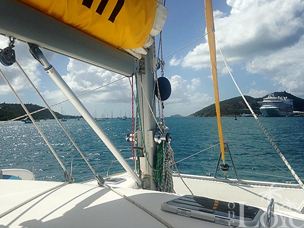
The land to the left in the image has the very creative name Water Island. The mark in the image, also shown on the chartlet below, definitely does designate a shipping channel. The thing is, there is a channel leading around each side of the island (West Gregerie Channel and East Gregerie Channel) and thus the Red-Right-Returning thing only applies to one of them. In this case, not the channel we were traveling in when taking this photo.

Just the other day we heard the radio traffic from a vessel’s Captain calling the USCG to say that he had run aground on that reef. Quite hard I imagine as his wife was injured in the process. My guess is that it was the boats anchored around the reef, giving the illusion of safe water, that confused him more than the mark itself. I don’t know for sure though as I haven’t spoken to him. As it turns out, our friends on s/v Harmony were anchored right there when the incident happened and may have been first on the scene. You can read more about this unfortunate drama on their cruising blog.
Hi,
Please excuse my question as I’m just a dreamer right now so now actual knowledge about navigation :).
Would this have been easily avoided if you had the right maps ? Or would they have benefited from some local knowledge ?
Thank you.
Either of the two.
There can be little excuse for not checking the chart before entering unknown waters. The unfortunate couple may have been from an area which uses the “A” system of navigation, which has reversed colours (not spelling mistake) from the “B” system. A lapse in concentration may have caused them to pass to the to the wrong side. The shape of the marker is important, and can overcome the challenge of entering a port which uses a system different to your own…. Port markers are flat, starboard markers pointed. (port and flat both have 4 letters)
The marker in the photo looks like it is flat topped, which would imply it is a port marker…..but that would make it system “A”.
It does appear to be flat, not pointed like a nun. It is definitely red though, and even numbered.
Just completely read your blog from start to finish. (Well up until today.) What an amazing story! Love reading about your daily adventures and issues. My wife and I have been on three chartered yacht trips in the BVI’s in the past and look forward to doing our 4th this coming late March/early April. (I mentioned this on your FB page.) We hope to meet up perhaps and have a few cocktails! Take good care and fair winds!
Peter T
Hi Peter. Thanks for following along. It takes a long time to wade through all of my posts!
I suspect that we’ll be in the BVI when you’re down here so please say hi if you see us.
In this photo, the closest marker on your port side is green ( though it is not visible in this photo), as you have just come through East Gregerie Channel. You have now essentially turned the corner, as evidenced by the fact that off your bow is the open sea. Therefore, you are no longer “returning” (requiring red on right) but outbound to sea, so of course you leave the red to port. If you were coming in West Gregerie, the red in the photo would safely be left to starboard. Pretty straightforward.
You’re right Jan, and to someone with local knowledge (like us?), or someone who has carefully looked at the chart, that can be seen. I would suggest that the green marker you mention does not make the situation any more clear. On the contrary, it makes it less so, to anyone unfamiliar with the area or who is not paying attention. Heading between that green and the red will take you right over the reef!
Hi Mike,
Some time back I recall you got a Milwaukee 28v right angle drill and winch adapter. And then someone sent you the white gussied up “marine” version of that to try. Any comments on either one? I am considering the Milwaukee. Thanks!
Jonathan
We have been using both. We use the Milwaukee on the large helm winch to raise the stern of the tender and the Winchrite on the davits to raise the bow.
this is why we have waypoints and know before hand what a safe heading will be up the channel having been in this channel I know that there is a green further up the channel on the north end of water island followed by a red on the same side of the channel which would indicate that you had begun to go back out to open water had you gone on the other side you would have the reds to your right until you reached the north end of water island ten the next buoy would be green indicating you were leaving the way you came in. there is nothing wrong with the buoyage.
Did I imply that there was something wrong with the bouyage? No.